Martha Sundquist State Forest
Size: 2,001 acres
Martha Sundquist State Forest, located in eastern Tennessee's Cocke County near the North Carolina-Tennessee border, is a unique and scenic destination. This 2,001-acre tract of land was purchased in 2001 from International Paper Company (formerly Champion International Corporation), which had owned the property since the 1930s. Before that, it was owned by the Lambs Gulf Company, giving rise to its long-standing nickname, "the Gulf."

As the only State Forest in the Blue Ridge province, Martha Sundquist State Forest is situated 70 miles east of Knoxville and is surrounded on three sides by the Cherokee National Forest. The forest features a single drainage system and is composed of mature mountain and cove hardwoods.
A harvest rotation schedule, established by previous owners, has been carefully followed, and significant streamside management zones—some as large as 80 acres—have been preserved.
The forest is a popular destination in East Tennessee for hiking, hunting, and fishing. During Cocke County's bear hunting season, hunting is permitted on state forest property, similar to private lands. This season is particularly popular and can lead to increased traffic on forest roads. Visitors should be cautious and mindful of the heightened activity during these times.
Additionally, while the North Cherokee Wildlife Management Area surrounds the state forest, it operates under separate regulations. You can learn more about bear hunting in Tennessee at the Wildlife Resources Agency.
Fire Tower Access
Fire towers on state forests are not open to the public. Visitors are welcome to photograph these structures but may not climb the towers.

This map shows Martha Sundquist State Forest in East Tennessee, including its boundaries, trail system and designated road and trail uses. The forest covers about 2,001 acres and is entirely surrounded by Cherokee National Forest. Access is via Martha Sundquist Road off Grassy Fork Road. Trails are designated for hiking only, horseback only, non-motorized use, which is open to hiking and horseback riding, or for tagged and registered vehicles only. The forest features primitive campsites, an information kiosk near the central trailhead area and a 9-mile horse route. Numbered loops include Mossy Camp Creek Loop, Gap Creek Loop and Big Hill Loop, along with the TN Gulf Trail along the eastern edge. Multiple gates are located at access points along the boundary and interior roads.
The information contained in the map is also available in the sections below. This map was most recently updated in April 2026.
This recreation map shows Martha Sundquist State Forest including its boundaries, road and trail system, primitive campsites and access points. Access to the forest is via Gulf Road, a county road, with the main forest entrance leading to an information kiosk near the central trailhead area.
Roads within the forest include Main Forest Road, also known as USFS Road 2251, and USFS secondary roads such as 225101 and 2250, which are recommended for high-clearance vehicles only. Bradley Shack Field Road runs along the eastern boundary.
Designated trails include the TN Gulf Trail at 3.5 miles, the Brown Gap Trail (Forest Service Trail 134) and a 9-mile horse route. Unmaintained trails include the Mossy Camp Creek Loop, Gap Creek Loop and Big Hill Loop. Seven numbered primitive campsites are located along the central road corridor near the information kiosk and along Big Hill Branch.
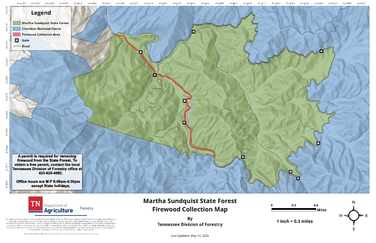
This map shows the designated firewood collection area within Martha Sundquist State Forest. The harvest area runs along Martha Sundquist Road through the central portion of the forest. Multiple gates are located along the firewood collection corridor and at access points throughout the forest boundary.
A permit is required to remove firewood from the state forest. Free permits are available from the local Tennessee Division of Forestry office at 423-625-4092, Monday through Friday from 8 a.m. to 4:30 p.m. except on state holidays. This map was most recently updated in May 2026.
This topographic map shows Martha Sundquist State Forest in relation to the surrounding Cherokee National Forest in East Tennessee. The state forest boundary is highlighted in orange and is bordered by national forest lands on all sides. Notable features within and around the state forest include Big Hill at 3,220 feet, Chestnut Ridge, Locust Horn Ridge and Snakeden Ridge. Surrounding terrain features include Big Bull Mountain, Laurel Mountain, Snowbird Mountain and Max Patch Mountain to the east. The Appalachian Trail and connecting national forest trails run along the southern and eastern edges of the map. National forest access points, parking areas and shelters are identified along these trail corridors, including facilities at Max Patch Mountain, Groundhog Creek and Harmon Den.
Contact
John Henderson, Area Forester
1250 Hwy 73, Newport, TN 37821
(423) 625-4092