State Route 31
Hawkins County
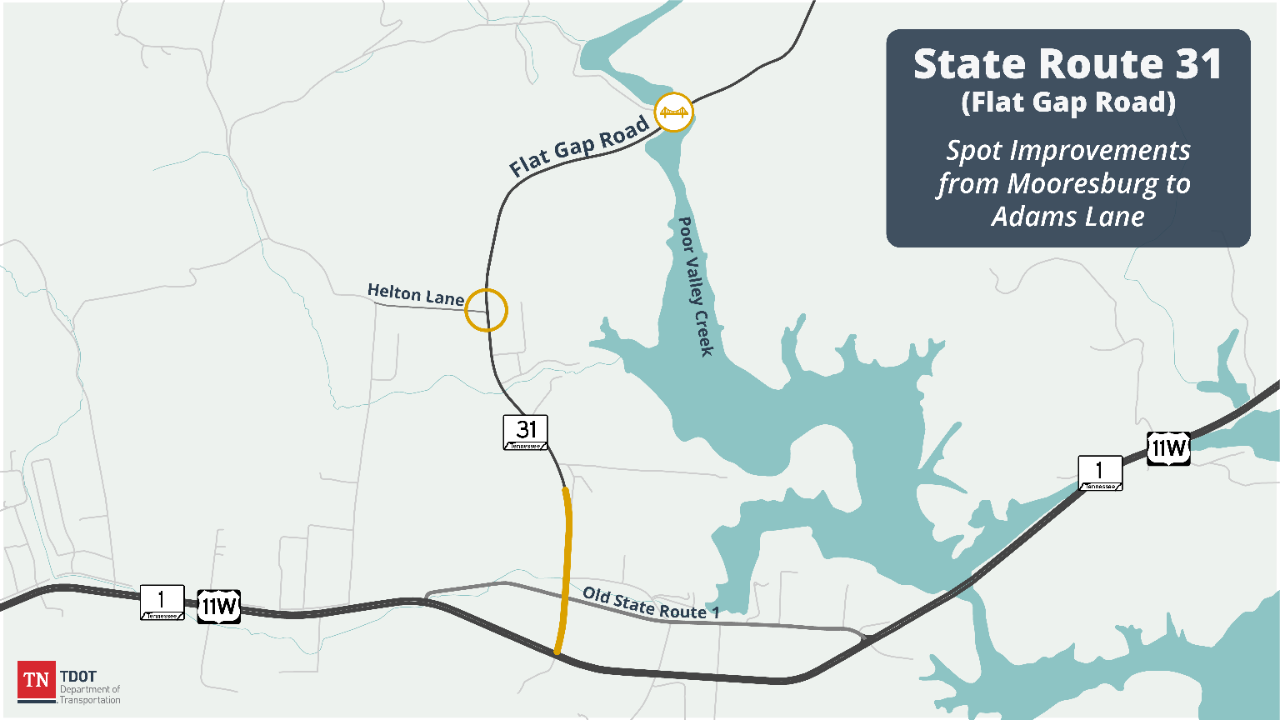
The Tennessee Department of Transportation (TDOT) is proposing to conduct spot improvements along 4.3 miles of State Route 31 in Hawkins County from SR 1 (US 11W) to Adams Lane. The spot improvements include widening, adding a turn lane at Helton Drive, and replacing the bridge over Poor Valley Creek. The purpose of the proposed project is to improve the safety and operation of SR 31 by correcting roadway deficiencies and addressing capacity issues at various locations along the route.
The existing route is a two-lane roadway. Previously proposed designs consisted of widening the route to a five-lane facility. As a result of public input and a re-evaluation of the state route, design plans have been scaled down to more efficiently serve the purpose and need of the project and the area.
This project is identified for funding in TDOT's 10-Year Project Plan with construction scheduled for Fiscal Year 2026.
Current Status: Design plans and right of way appraisal and acquisition are currently underway.
Estimated construction start: Fiscal Year 2026
Estimated completion*: TBD
Funding Source: TDOT anticipates that this project will be funded in part through the Transportation Modernization Fund.

History and Background
State Route 31 is a rural minor arterial highway between the community of Mooresburg in Hawkins County and the community of Treadway in Hancock County. It connects to State Route 1 (US 11W, Lee Highway) at the south end of the route.
Currently, SR 31 has sharp curves, limited sight distance, narrow lanes and shoulders, and a lack of turn lanes at congested intersections that impact the safety and mobility of the route.
The newly proposed design consists of spot improvements along SR 31 between SR 1 and Adams Lane. The improvements are proposed at the following three sections or segments.
Section 1 – From SR 1 (US 11W) to Jarnigan Road
- From SR 1 (US 11W) to near Old SR 1
- Two 12-foot travel lanes (one lane in each direction)
- 12-foot dedicated center turn lane
- 8-foot shoulders
- From near Old SR 1 to near Jarnigan Road
- Two 12-foot travel lanes (one lane in each direction)
- 12-foot dedicated center turn lane
- 8-foot shoulders
- Curb-and-gutter
Section 2 – Intersection at Helton Lane
- Two 12-foot travel lanes (one lane in each direction)
- 12-foot left turn lane from SR 31 North to Helton Lane
- 4-foot shoulders
Section 3 – Bridge over Poor Valley Creek
- Bridge replacement
- Two 12-foot travel lanes (one lane in each direction)
- 12-foot shoulders

Public Involvement and Engagement
A Design Public Meeting was held September 8, 2020.
Public Meeting Presentation (PowerPoint)
Section 1 Display (PDF)
Section 2 Display (PDF)
Section 3 Display (PDF)
Public Meeting Handout (Word)
A Design Public Meeting was held November 1, 2012.
Design Public Meeting Presentation (PowerPoint)
Project Contacts
Mark Nagi
TDOT Region 1 Regional Communications Officer (media)
Phone: 865.594.0161
Email: Mark.Nagi@tn.gov
Tracie Widner
TDOT Region 1 Project Management
Email: Tracie.Widner@TN.gov