Memorial Boulevard (State Route 126)
Sullivan County
The Tennessee Department of Transportation (TDOT) is proposing to construct improvements to State Route 126 (Memorial Boulevard) in Sullivan County in order to provide a safe, efficient route for local traffic between the City of Kingsport and Interstate 81.
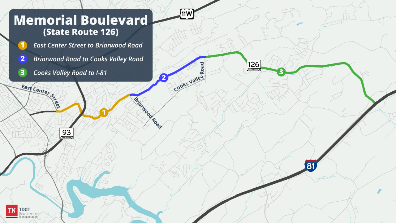
The improvements to SR 126 will extend approximately 8.3 miles, from East Center Street in Kingsport to I-81. After all improvements are complete, SR 126 will include 4 travel lanes from East Center Street to Harbor Chapel; 3 lanes, including two travel lanes and one eastbound truck climbing lane, from Harbor Chapel to Old Stage Road; 3 lanes from Old Stage Road to Harr Town Road in the vicinity of East Lawn Cemetery and Yancey’s Tavern; and 2 lanes from Harr Town Road to I-81. Additionally, bike lanes and sidewalks will be constructed along portions of the corridor.
Due to the size of this project, TDOT has split improvements to SR 126 into three phases. Phase 1 of improvements is from East Center Street to east of Briarwood Road, and is identified for construction in TDOT's 10-Year Project Plan, with construction scheduled for Fiscal Year 2025.
Current Status: Phase 1 is funded 100% through the Transportation Modernization Fund. Phases 2 and 3 are awaiting funding.
Estimated construction start: Phase 1, from East Center Street to east of Briarwood Road: Fiscal Year 2025.
Estimated completion*: TBD
Funding Type: Phase 1 is funded 100% through the Transportation Modernization Fund.

History and Background
Several design alternatives were considered in an effort to meet the purpose and need of the SR 126 improvement project. The project was the initial Context Sensitive Solutions (CSS) project for Tennessee, in which improvements are designed to be sensitive to the context of the different land uses along the corridor. TDOT consulted with local, state and federal officials and agencies, identified environmentally sensitive areas and held several public involvement meetings regarding the corridor project. Initially, two build alternative options, Alternatives A and B, and the No-Build Alternative option were presented in the Draft Environmental Impact Statement (DEIS). Since publication of the DEIS, the travel model used for this project was updated and updated traffic information has been made available. With that information, TDOT developed an additional alternative option for consideration, referred to as Modified Alternative B. This alternative was selected because it improves safety while minimizing the impacts to the environment and the community. It does not take graves from East Lawn Cemetery or present an adverse effect to Yancey’s Tavern, and it considerably lowers the number of residential and business displacements.

Public Involvement and Engagement
A Design Public Meeting was held on November 19, 2015, at Sunnyside Baptist Church.
Public Meeting Handout (pdf)
Public Meeting Presentation (pdf) (large file 13 MB)
Map Display 1 (pdf)
Map Display 2 (pdf)
Map Display 3 (pdf)
A Public Hearing was held on December 11, 2012, at Kingsport Civic Center Auditorium.
Draft Environmental Impact Statement (DEIS) (pdf) (large file 16 MB)
Appendix for DEIS (pdf) (large file 14.6 MB)
Public Hearing Handout (pdf)
Map Displays:
Alternate A (Sheet 1 of 2)
Alternate A (Sheet 2 of 2)
Alternate B (Sheet 1 of 2)
Alternate B (Sheet 2 of 2)
Alternate B Modified (Sheet 1 of 2)
Alternate B Modified (Sheet 2 of 2)

Project Imagery & Visuals

Key Project Milestones
| East Center Street to east of Briarwood Road |
|
|---|---|
| Right-of-way | Underway |
| Construction | Fiscal Year 2025 (planned) |
| East of Briarwood Road to east of Cooks Valley Road |
|
| Right-of-way | Underway |
| Construction | Unknown (not identified for funding in TDOT's 10-Year Project Plan) |
| East of Cooks Valley Road to Interstate 81 | |
| Right-of-way | Unknown (not identified for funding in TDOT's 10-Year Project Plan) |
Project Contacts
Mark Nagi
TDOT Region 1 Regional Communications Officer (media)
Email: Mark.Nagi@tn.gov
Phone: 865.594.0161
Eric Wilson, PE
TDOT Region 1 Project Management
Email: Eric.Wilson@tn.gov
