Mound Bottom State Archaeological Area
Drone footage of Mound Bottom courtesy of Harpeth River State Park and Hawkeye Media.
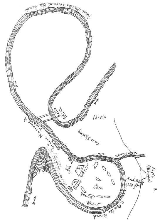
Mound Bottom State Archaeological Area is an ancient Native American mound center in Cheatham County, Tennessee that dates to the Mississippian period of regional prehistory (ca. 1000–1350 CE). The site core includes at least 12 earthen mounds oriented around a 7-acre plaza within a meander bend of the Harpeth River. The Mound Bottom site is owned and protected by the State of Tennessee and included on the National Register of Historic Places, the National Park Service’s program to identify, evaluate, and protect America's historic and archaeological resources.
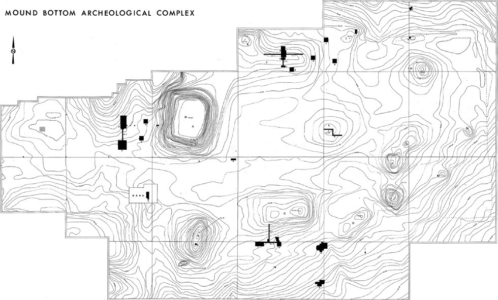
The meander bend containing the Mound Bottom site was farmed for nearly a century prior to its purchase by the State of Tennessee, and as a result historic plowing has altered the original size and shape of the mounds surrounding the main plaza. The largest mound at the site, Mound A, is a platform mound which today measures approximately 246 feet along each side and stands approximately 36 feet tall. Mound A was constructed in at least four stages beginning around 1000 CE, and would have originally supported one or more structures on its summit. The remaining mounds surrounding the plaza today measure between 2 and 13 feet tall. Archaeological evidence suggests most of these mounds were originally flat-topped and, like Mound A, built to support structures on their summits. Geophysical survey and remote sensing data reveal that Mound Bottom was not a vacant ritual center, but that instead structures or residences were present throughout the site, including around the base of the mounds.
Artifacts suggest Mound Bottom was founded during the early eleventh century CE by outsiders who arrived in the Middle Cumberland region from the American Bottom in modern day Missouri and Illinois. These individuals likely had some connection to the paramount Mississippian site of Cahokia, which is today located across the Mississippi River from the city of St. Louis. Archaeological data from the Middle Cumberland region suggest that Mound Bottom grew as a regional center during the 12th and 13th centuries CE, expanding its sphere of influence first along the Harpeth River drainage and then eastward through the Nashville Basin. As Mound Bottom’s influence extended it supplanted or subsumed various small, local chiefdoms, while simultaneously incorporating aspects of regional cultural traditions.
Major occupations at Mound Bottom ended by around 1350 CE, at a time when the Middle Cumberland region witnessed an overall decentralization of political authority. Although it saw occasional small-scale reuse after that time, Mound Bottom would never again be intensively occupied. While some smaller mound centers in the Middle Cumberland continued to be active after 1350 CE, settlements in the region largely shifted away from mound centers and to fortified village sites. Shortly after this point, population in the Middle Cumberland region of Tennessee seems to decline rapidly, and Mississippian occupations largely vanish from the area by 1425 CE. The specific factors which brought about the end of the Mississippian period in the Middle Cumberland remain the subject of ongoing investigation. However, emerging evidence suggests that regional climate shifts and particularly a multi-generational drought may have exacerbated political instability.
The Mound Bottom site was acquired by the State of Tennessee in 1973, and today is managed as part of the Harpeth River State Park. In order to protect and preserve this unique resource, access to Mound Bottom is prohibited without permission of the Harpeth River State Park or Tennessee Division of Archaeology. For information on upcoming tours of the site or with questions regarding accessibility, please see the Harpeth River State Park: https://tnstateparks.com/parks/harpeth-river#happenings .
The following literature links are archived content, provided for reference purposes only and not maintained to current accessibility standards.