State Route 30
Rhea County
The Tennessee Department of Transportation (TDOT) is proposing to construct improvements on State Route 30 in Rhea County. The proposed work includes reconstruction and widening of SR 30 from SR 29 in Dayton to west of the Tennessee River. The project corridor is approximately eight miles.
The purpose of these improvements is to support economic development (and to become an east-west regional economic corridor); improve regional mobility (and serve as an evacuation route in the event of a disaster at either Watts Bar Dam and Nuclear Plant or Sequoyah Nuclear Plant); and improve safety and correct geometric deficiencies — the route possesses geometric deficiencies with respect to lane and shoulder widths, and a high crash rate at the junction with SR 29 compared to the statewide average.
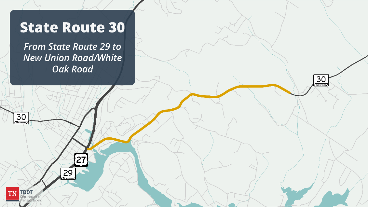
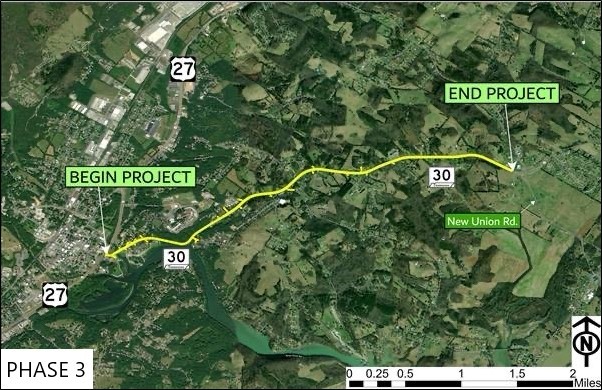
Due to the size of the proposed improvements to SR 30, TDOT has split the project into four segments. One segment, consisting of miscellaneous safety improvements throughout the corridor, was completed in 2016. The second segment, from the intersection with New Union Road/White Oak Road to Sky Drive, has also been completed. The third segment, from SR 29 to near the intersection with New Union Road/White Oak Road, is identified for funding in TDOT's 10-Year Project Plan, with construction scheduled for Fiscal Year 2030.
Current Status: Project design is underway for the third segment (shown in map above).
Estimated construction start: Fiscal Year 2030.
Estimated completion*: TBD
Funding Type: TDOT anticipates that a portion of this project will be funded through the Transportation Modernization Fund.

History and Background
The City of Dayton is located approximately 36 miles northeast of Chattanooga and is the seat of Rhea County. SR 30 is the primary east-west route in the area, providing a connection between the cities of Dayton and Athens and access to Interstate 75. There are two nuclear power plants near the corridor: Watts Bar Nuclear Plant to the northeast and Sequoyah Nuclear Plant to the southwest near Chattanooga. SR 30 is a designated eastern evacuation route in case of failure at either plant.
The Highway 30 Economic Development Coalition and the Southeast Tennessee Development District Rural Planning Organization (RPO) began planning for the corridor in 2006. In 2007, work began on a Transportation Planning Report (TPR), which was approved by TDOT in February 2008. The TRP and subsequent public involvement identified six corridor build alternatives. Analysis began on the alternatives, systematically eliminating alternatives for further study.
A Conceptual Study was completed by TDOT in 2016, reducing the two remaining alternatives to one proposed option. Based on recommendations from the Study, the project was split into four sections or phases. The first phase of work consisted of miscellaneous safety improvements to address roadway departures. Construction was awarded for this work in 2016 and is complete. The remaining three phases divided the corridor into three sections:
- Segment 2 included safety improvements on SR 30 from west of New Union Road/White Oak Road to Sky Drive. This project was expedited due to ongoing safety concerns at this intersection, and construction is complete.
- Segment 3 proposes to widen and improve geometry along SR 30 from near SR 29 to west of new Union Road/White Oak Road. Additionally, the bridge over Little Richland Creek will be replaced. This segment is funded for construction in TDOT's 10-Year Project Plan.
- Segment 4 proposes to widen and improve geometry along SR 30 from near Sky Drive to west of the Tennessee River Bridge. This segment is awaiting funding.

Public Involvement and Engagement
Development of the project will include an Environmental Assessment as part of the National Environmental Policy Act (NEPA), which includes public meetings.
November 18, 2025 Public Meeting Materials:
November 18, 2025 Public Meeting Handout
November 18, 2025 Public Meeting Postage Paid Comment Card
November 18, 2025 Public Meeting Display November 18. 2025 Public Meeting Presentation
Public comments can be provided by emailing TDOT.comments@tn.gov using the subject line “State Route 30 Project” or by calling (423) 510-1227. Please leave a voicemail message with your name, phone number, and question and/or comment. For questions - Please make sure to call the number above by December 2, 2025, to allow TDOT to provide you a response by December 9, 2025, the comment deadline. A TDOT representative will respond within 7 business days.
Public comments can also be submitted electronically utilizing an online comment form available here.
Public Comments received or postmarked by December 9, 2025, will be included in the official summary of the public hearing and incorporated into the final environmental document currently under development.

Project Imagery & Visuals

Project Contacts
Rae Anne Bradley
TDOT Region 2 Regional Communications Officer (media)
Phone: (423) 510-1164
Email: Rae-Anne.Bradley@tn.gov
Erin Woodson
TDOT Region 2 Project Management
Phone: (423) 510-1227
Email: Erin.Woodson@tn.gov
*Subject to change