Land Surveyors - Plat Requirements: Example Boundary Plat
Frequently Asked Questions Regarding Plats Supplied with an Application Pursuant to Tenn. Comp. R. & Regs. § 0820-01-.02(1)The responses below were adopted by the Tennessee Board of Examiners for Land Surveyors on April 12, 2018 and are not meant to define or explain the meaning of any statute or rule. Instead, these FAQs are only intended to provide examples and answers to common questions to further demonstrate what a plat provided with an application in compliance with Tenn. Comp. R. & Regs. § 0820-01-.02(1) might look like. The responses below should not be viewed as comprehensive, and registrants are urged to contact the Board office for questions that are not addressed in this document. This document is not intended to create any substantive or procedural rights, enforceable by any party in administrative and judicial litigation with the State of Tennessee. The Tennessee Board of Examiners for Land Surveyors reserves the right to review any plat provided with an application before it on the specific facts of that matter.
- Must a plat and written survey legal description provided under Tenn. Comp. R. & Regs. § 0820-01-.02(1) be for a property in Tennessee?
- No. Tenn. Comp. R. & Regs. § 0820-01-.02(1) does not set out from which jurisdiction the plats must be. As such, the survey may be of a property from another state in which you or the Surveyor in responsible charge is currently licensed
- Does the survey on which the plats are based need to be complicated?
- No, Tenn. Comp. R. &Regs. & 0820-01-.02(1) does not set out how complicated the survey and plat should be. The purpose of the plat submitted is to demonstrate that the applicant and/or the surveyor in “responsible charge” understand the current applicable requirements of Chapter 0820-03 (Standards of Practice as they apply to a General Property Survey. The plat can meet any contractual requirements, ALTA/NSPS requirements or local jurisdiction requirements (state or regional planning) however they must clearly include all the requirements detailed in Chapter 0820-03 even if the contractual requirements exceed Chapter 0820-03. The plat may include additional survey types such as Topographic Surveys, Remote Sensing Surveys and Hydrographic Surveys. However, the applicant must be aware that these additional elements will be reviewed for compliance with Chapter 0820-03 and do not replace the requirement to submit all the elements of a General Property Survey. In addition, plats and descriptions need to demonstrate that the applicant has checked the boundary call on the plat and description for mathematical closure meeting requirements of Chapter 0820-03. A property with only 4 sides and simple geometry will NOT demonstrate this and will not be accepted.
- What standard must the plats meet?
- Tenn. Comp. R. & Regs. § 0820-01-.02(a) requires that the plats must meet all current applicable requirements of Chapter 0820-03 (Standards of Practice) and must bear the seal and signature of the supervising registered land surveyor, if the plats were performed under supervision (i.e., the applicant was not licensed in the jurisdiction in which the plats were created). As such, the survey, while it may be of a property from another state, must contain all the required elements, notes, certifications, and other requirements for a general property survey in the State of Tennessee (For Survey Types and Requirements, see Tenn. Comp. R. & Regs. § 0820-03-.07). As noted above, the plat need not be changed to read as if it were performed in Tennessee. The information contained in the required notes may reflect the true information of the actual survey location. For example, if the survey is of a property that lies in XX City, YY County, and ZZ State, the plat may read as such.
- Must the plat be stamped/sealed?
- Yes, as stated above, the plat must meet all current applicable requirements for a plat in Tennessee, which includes being marked with the stamp/seal of the supervising registered land surveyor in responsible charge of the plats who supervised you. The plats and descriptions must be accompanied by a detailed narrative of the applicant’s role in the performance and production of the two sample plats. The narrative must be signed and marked with the stamp/seal of the supervising registered land surveyor and the applicant’s role must be approvable by the Board. These plats shall be in compliance with Tenn. Comp. R. Regs &0820-030.07(1)(a). If the plats are of property in a state which you are actively licensed, you may stamp/seal the plat as the supervising registered land surveyor. In this case, because the plat shall be modified to meet all current applicable requirements for a plat in Tennessee and it should be marked “FOR DEMONSTRATION PURPOSES” or a similar notation to ensure the security of the plat.
- Must the Surveyor’s Certification meet certain requirements?
- Yes. Tenn. Comp. R. & Regs. § 0820-03-.07(1)(b)7. Sets out the information that must be on the face of the final plat. That rule, in pertinent part, reads as follows:
- A certification on the face of the final Survey Map or Survey Plat as to the category of the survey and the ratio or precision of the unadjusted survey, which shall have the following minimum content:
- Certification as to category I, II, III and/or IV and the survey meets or exceeds the accuracy requirements thereof.
- Signature
- Registration number
- Date
- A certification on the face of the final Survey Map or Survey Plat as to the category of the survey and the ratio or precision of the unadjusted survey, which shall have the following minimum content:
- Yes. Tenn. Comp. R. & Regs. § 0820-03-.07(1)(b)7. Sets out the information that must be on the face of the final plat. That rule, in pertinent part, reads as follows:
- Is there a standard for written land descriptions?
- Yes. The written description shall be a metes and bounds composed with the assumption that the public may not have access to the plat. It must describe the property as completely as the plat and include all the elements specified in Tenn. Comp. R. &Regs. & 0820-03-.09 and citing the source survey.
- Is there an example of a plat that would comply with the requirements available that I can review?
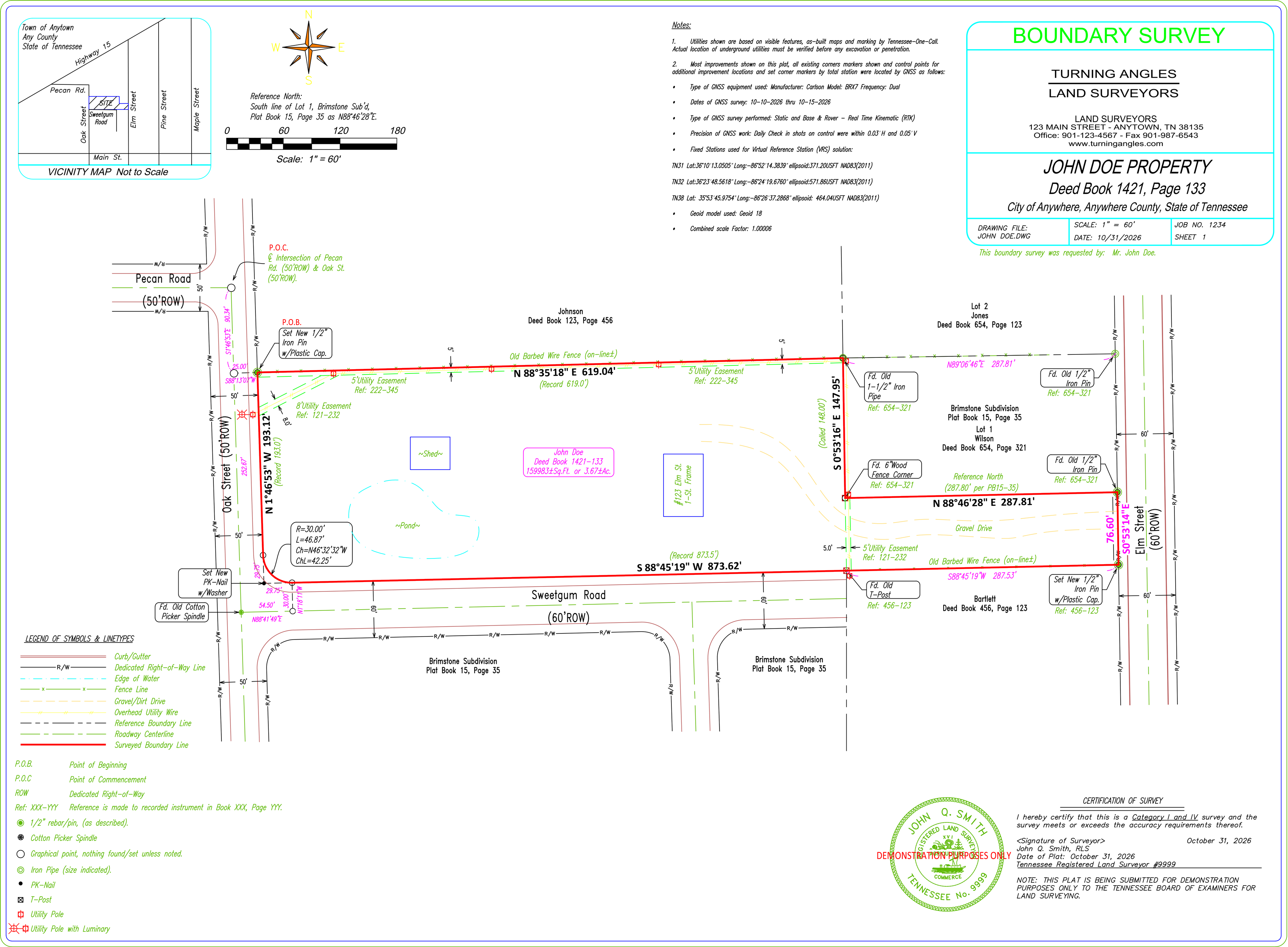
- Yes. Below is an example of a fictitious plat that demonstrates the general form and format of an acceptable plat. The applicant is responsible for adding or modifying any elements of their submitted plats and descriptions to comply with their situation and the current requirements of Chapter 0820-03 to demonstrate their and/or the surveyor in “responsible charge” understanding of said requirements.
- Who should I contact with any questions?
- Please contact our Board staff at 615-741-2241 prior to submitting a plat or regarding any other matter.
Sample notes for Rule 0820-03-.07(5)(a) Minimum Standards for Remote Sensing Surveys
Example 1
GNNS Note: Most improvements shown on this plat and existing property corners 1-6 along the southerly and easterly boundaries were located by the following:
- Type of GNSS equipment used:
- Manufacturer: Carlson Model: BRX7 Frequency: Dual
- Dates of GNSS survey: 10-10-2026 thru 10-15-2026
- Type of GNSS survey performed: Static and Base & Rover - Real Time Kinematic (RTK)
- Precision of GNSS work: Daily Check in shots on control were within 0.03’H and 0.05’ V
- Fixed Stations used for Virtual Reference Station (VRS) solution:
- TN31 Lat:36°10’13.0505” Long:-86°52’14.3839” ellipsoid:371.20USFT NAD83(2011)
- TN32 Lat:36°23’48.5618” Long:-86°24’19.6760” ellipsoid:571.86USFT NAD83(2011)
- TN38 Lat: 35°53’45.9754” Long:-86°26’37.2868” ellipsoid: 464.04USFT NAD83(2011)
- Geoid model used: Geoid 18
- Combined scale Factor: 1.00006
Example 2
GNNS Note: Most improvements shown on this plat and existing property corners 1-6 along the southerly and easterly boundaries were located by the following:
- Type of GNSS equipment used:
- Manufacturer: Trimble Model: R12i Frequency: Dual
- Dates of GNSS survey: 10-10-2026 thru 10-15-2026
- Type of GNSS survey performed: Base & Rover - Real Time Kinematic (RTK)
- Precision of GNSS work: Daily Check in shots on control were within 0.05’H and 0.05’ V
- Fixed Station used to set control points from NTRIP Closest Station:
- TN31 Lat:36°10’13.0505” Long:-86°52’14.3839” ellipsoid:371.20USFT NAD83(2011)
- Geoid model used: Geoid 12B
- Combined scale Factor: 1.00000 (Grid)